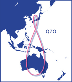
What is the Quasi-Zenith Satellite System (QZSS)?
Why is QZSS required today?

Main area where QZSS is avalable
Navigation functions—such as those used in car navigation systems, smartphones, and mobile phones—have come into widespread usage because they are very convenient. These convenient functions use positioning signals from satellites for satellite positioning services that make it possible to detect your current location. These services are also used in fields such as surveying, disaster prevention, etc.
However, the satellite positioning services so far had utilized GPS satellites operated by the United States. Due to reasons such as the small number of satellites in the field of vision, services were not always stable.
QZSS (Michibiki) has been in operation since November 2018 to develop a satellite positioning service that can be used stably in all locations at all times. This system is compatible with GPS satellites and can be utilized with them in an integrated fashion. In this way, the satellite positioning service environment was advanced dramatically.
QZSS can be used even in the Asia-Oceania regions with longitudes close to Japan, so its usage will be expanded to other countries in these regions as well.
Satellite deployment plan
The first Quasi-Zenith Satellite (QZS-1) was launched on September 11, 2010, and the Japan Aerospace Exploration Agency (JAXA) operated QZSS.
Afterward, the cabinet decided in September 2011 that the government would establish a four-QZS constellation and complete a seven-QZS constellation in the future. This system is also regarded as an important political measure in the Basic Plan on Space Policy of January 2013.
Due to these circumstances, the government decided to develop the additional three satellites (two with a quasi-zenith satellite orbit [QZO] and one with a geostationary orbit [GEO]), which were launched the second through fourth satellites in FY2017. In this way, a four-satellite constellation has been operated since November 2018. Development and operation are conducted via a private finance initiative (PFI) project and Quasi-Zenith Satellite System Services Inc. (QSS) operates the four satellites, including QZS-1. Subsequently, in FY2021, the successor to the QZS-1R was launched and operations of QZS-1 were suspended.
In the " Implementation Plan of the Basic Plan on Space Policy " revised in December 2022, it is stated that "In order to establish a seven-satellite constellation, QZSS satellites will be launched sequentially from FY2023 to FY2024 based on the development status of the H3 launch vehicle, and development and maintenance of the satellites will be steadily promoted.

Satellite deployment plan
Increasing the number of QZS to improve positioning stability
Many positioning satellites must be flown in the sky, and satellites must be constantly visible near the zenith, to improve multipath errors (caused by reflection off buildings and other objects) and errors caused by satellite placement, as well as to provide stable positioning accuracy.
Positioning satellites are almost always in the direction of the zenith since QZSS became a four-satellite constellation in November 2018. Because signals can be obtained from more positioning satellites than before, accuracy is more stable even in urban areas and mountainous areas with poorer visibility due to buildings and trees.
QZSS will become a seven-satellite constellation in the future, and four or more QZS will always be available for positioning around Japan. This will provide even better accuracy and enable positioning using only QZSS.
Positioning with multiple frequencies to resolve ionospheric errors
To resolve ionospheric errors, it is necessary to perform positioning that combines multiple frequencies (L1 with L2 or L5). The initial-stage GPS satellites—excluding military frequencies—had only one frequency, but the latest GPS satellites have multiple frequencies. All four QZS can transmit multiple frequencies, including the first satellite.
In addition to increasing the number of multi-frequency GPS, by using it in an integrated way with QZS, it will make it possible to approach precise positioning accuracy.
| Number of multi-frequency satellites(consumer use) | Total | GPS | QZS |
|---|---|---|---|
| 2021 | 27 satellites (20 for L5) | 23 satellites (16 for L5) | 4 satellites |
| 2027 (forecasted) | 36 satellites (29 for L5) | 29 satellites (22 for L5) | 7 satellites |
END
---------------------
qzss.go.jp-->JINLING


